

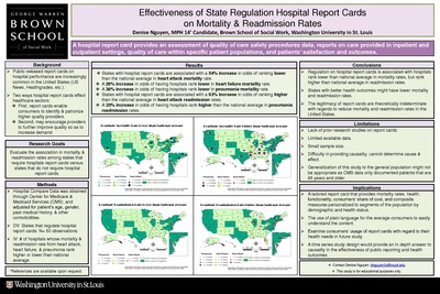
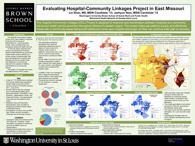
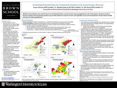
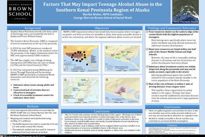
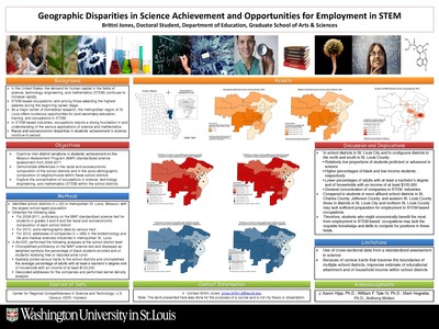
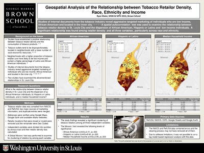
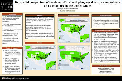
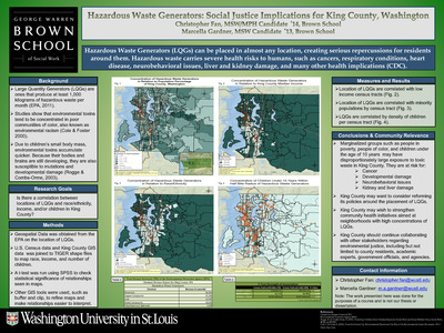
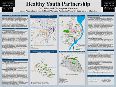
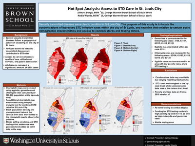
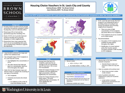
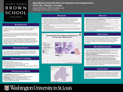
Course description: This course will familiarize students with the basic knowledge of geographic information systems (GIS) and their application to social work practice and research. The course is organized around three primary areas: 1) conceptual; 2) technical; and 3) data management. A conceptual overview of GIS is presented to provide students with foundational knowledge about the theory, purpose, function, and applicability of GIS in practice and research settings. Students will develop critical thinking skills necessary to devise research questions appropriate for a GIS, to develop a GIS, interpret the findings, and to evaluate the spatial relationships between variables.
-

Old North St. Louis Residents’ School Choices and Accessibility
Rachel Brown
5-7-2013This project looks at what patterns can be seen in the educational landscape of students from Old North, how far students travel to go to school, amd how far is it by public transit from home to school.
-

Penrose Park Velodrome
Andrea Roelofs
12-1-2013This project aims to identify characteristics of those people living within a walking distance from Penrose Park; identify comparable Velodromes in the United States to serve as a model for redevelopment; provide research for the Penrose Park Steering Committee.
-

Pharmacy Access for Diabetes Patients in North St. Louis
Brittney Francis
5-7-2013This project aims to investigate the disparities within St. Louis City and access to pharmacies and to see how accessible pharmacies are in North St. Louis by bus route.
-

Positive and Negative Community Facilities and Their Relationship to Crime in the Isaac School District
Dessa Somerside Schuckerow
7-1-2013This project aims to answer the following questions: are there blocks with higher crime incidences in the Isaac School District? What is the relationship between the high-crime blocks, schools, community resources, and facilities with liquor licenses?
-
 Restaurant Meals Program (RMP)(San Diego County - Zip Code 92105) by Timothy P. Walter")
Potential Outreach Sites for CalFresh (SNAP) Restaurant Meals Program (RMP)(San Diego County - Zip Code 92105)
Timothy P. Walter
7-1-2013This project examines the potential qualifying food options within zip code 92105. It asks where are the cluster zones of potential RMP sites within Homeless & Senior buffer zones.
-

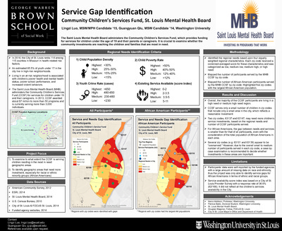
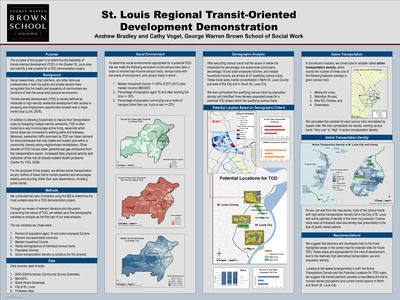
Potential Sites for a Future Mental Health Agency in the Kansas City Region
Pichaya Adakul and Lydia Kim
7-1-2013The focus of this project is to investigate change over time in the levels of stigma against individuals with mental illness in the nine metropolitan statistical areas (MSAs) of Missouri and locate potential sites for future development of a new mental health service agency focused on advocacy and educational initiatives.
-

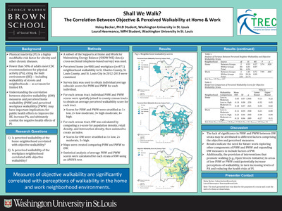
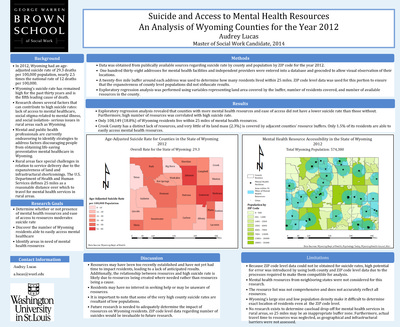
Rates of Crime: Accessing Mental Health Services for Juveniles
Katy Wolfe
7-1-2013This project seeks to identify areas that have a high crime rate and a high percent of population under 18 years old, to identify mental health facilities available in St. Louis City for youth under the age of 18 years that are financially accessible (i.e. offers payment assistance plans, accepts wide range of insurance), and to detect cluster areas that are being over-served and detect areas that are being under-served.
-

Redevelopment in North St. Louis City
Jacqueline Wagner
12-1-2013This project seeks to answer the following questions: what is the current state of property in the study area? What areas may be best suited for redevelopment? What types of redevelopment are suitable and feasible?
-

Relationship Between Population and Evacuation Capacity of Shelters in Greater St. Louis area
Neerja Chavakula and Bowen Sitzes
12-1-2013The goal of the project is to determine patterns or association between population density and shelter density and to answer the questions of whether areas in Greater St. Louis area with high population density have high number of shelters and what are the potential areas for shelter development.
-

Spatial relationship between youth-directed services and crime incidence in Chicago, IL
Lauren Fischer
12-1-2013This project aims to answer the questions of what is the spatial relationship between the locations of youth-directed services and areas of high crime incidence in the city of Chicago and whether areas with youth programs differ significantly in patterns of crime incidence from areas without programs.
-

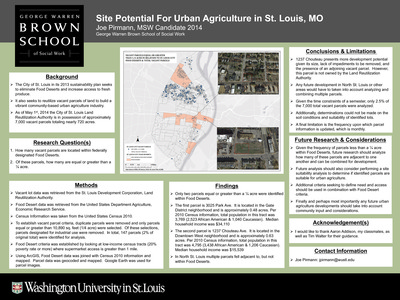
St. Louis Arc Supported Employment: Locating Undeveloped Areas for Potential New Job Sites
Jessica Steinberg
7-1-2013This project investigates which areas of the Greater St. Louis Metropolitan region would be the most effective places for the St. Louis Arc Supported Employment program to focus job site development.
-

Targeted Outreach: Grassroots Organizing for theSierra Club Anti-Pipeline Campaign
David Schafroth
7-1-2013The goals of this project are Geocoding the Flanagan South Pipeline, Geolocating individuals who will be most impacted by the proposed pipeline, and creating a database for the Sierra Club to prioritize outreach efforts.
-

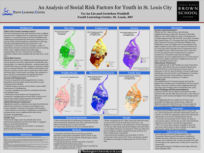
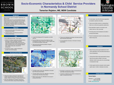
The Effect of Family Socio-economic Status on Academic Performance A Study of Public High School Achievement in St. Louis City
Ming Yin
12-1-2013The aim of this project is to see whether concentrated poverty of households and race are related to the educational outcomes of public high schools, especially to neighborhood schools.
-

The Interplay Between Alcohol Abuse, Race, and Poverty: An analysis of Missouri counties, 2010
Sarra Latif
7-1-2013This project explores the relationship between alcohol abuse, race/ ethnicity and poverty across Missouri counties.
-

The Relationship Between Poverty Level of Communityand Educational Outcomes in Missouri
Eun Jung Lee
5-7-2013This project seeks to answer the following questions: is poverty level of communities associated with educational attainment of population? Is poverty level of communities associated with Missouri Assessment Program (MAP) in Math? Is poverty level of communities associated with Missouri Assessment Program (MAP) in Communication Arts?