

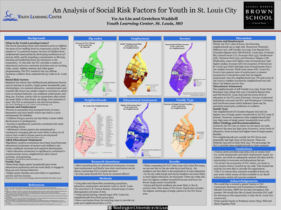
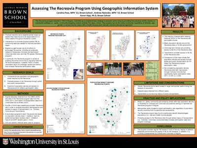
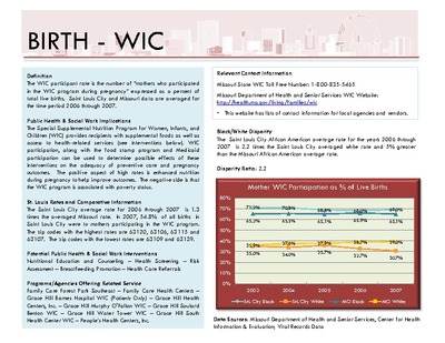
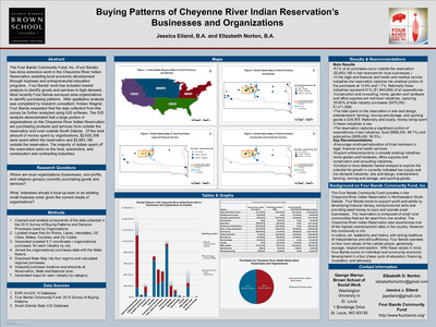
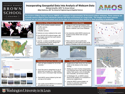
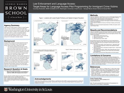
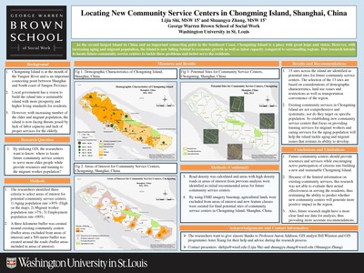
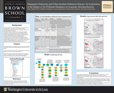
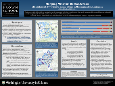
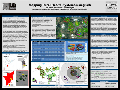
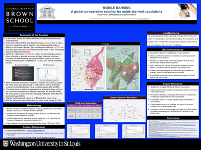
Course description: This course will familiarize students with the basic knowledge of geographic information systems (GIS) and their application to social work practice and research. The course is organized around three primary areas: 1) conceptual; 2) technical; and 3) data management. A conceptual overview of GIS is presented to provide students with foundational knowledge about the theory, purpose, function, and applicability of GIS in practice and research settings. Students will develop critical thinking skills necessary to devise research questions appropriate for a GIS, to develop a GIS, interpret the findings, and to evaluate the spatial relationships between variables.
-

Transportation Analysis for Future Parenting Classfor New American Preparatory Academy (NAPA
Kelly Collingwood
7-1-2013This project aims to question what the best transportation option is, concerning time and cost, for the families and NAPA to ensure 75% attendance rate at the parenting class?
-

Volcanism in Ecuador: Assessment of Disaster Preparedness
Jenna Cameron
5-7-2013This project examines 2007 survey data relating to preparedness and volcanism through geospatial representation and develops recommendations for future research focused on preparedness.
-

West End Community Gardens
Stephanie Larson
7-1-2013This project locates West End community gardens in relation to select social determinants, including income level, occupier's ownership status, ethnic diversity, and population density.
-

Who Accesses Zoo and Science Center Programming?Using Geospatial Data to Find Patterns of Participation
Erin Nolan
12-1-2013This project investigates how proximity to the institution correlates to participation in museum programming, and how this compares to the status of being in or out of the ZMD? And how does zip-code area income level correspond to participation in institution programming?
-

Diabetes and the Built Environment: Do perceptions matter?
Henry Heisey and Anne Herleth
12-1-2012This project explores whether PAPAR variables can predict diabetes status when controlling for household income and race.
-

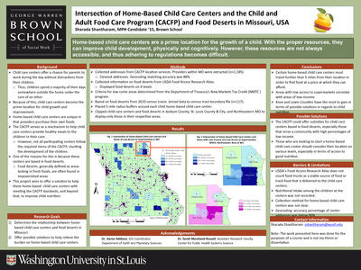
Environmental Risk Factors for Low-Income Home-Based Childcares in St. Louis
Edison Laura and Elizabeth Alden
12-1-2012Through the examination of environmental factors, this project looks to identify home-based childcare facilities in St. Louis City and County at risk for ineffective implementation of CACFP’s anticipated new guidelines.
-

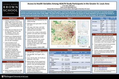
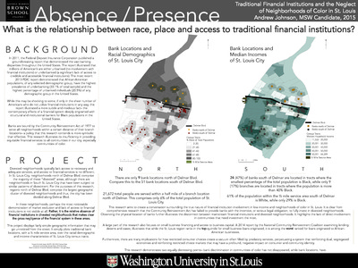
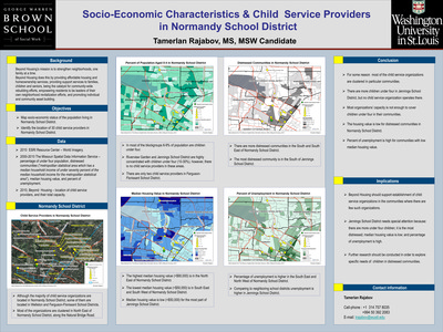
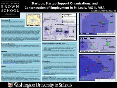
Financial Institutions in the Normandy School District
Melanie Seawright
7-9-2012The goals of this project are to determine the extent of financial institutions in and near the Normandy School District, understand the physical accessibility of financial institutions to residences and the proximity to public transportation, and determine if there is a relationship between the location of the financial institutions and the income and crime levels.
-

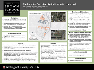
Food Deserts & Obesity Prevalence in Missouri
Emily Bull
7-9-2012This project investigates how food deserts are related to the prevalence of obesity in the state of Missouri.
-
 by Yujun Liu and Evelyn Sharkey")
Free and Low-Cost Health and Social Services in St. Louis City and County Available to Clients of the SPOT (Supporting Positive Opportunities with Youth)
Yujun Liu and Evelyn Sharkey
12-1-2012This project maps the spatial distribution of youth in St. Louis City and County who visited the SPOT between January 2011 and June 2012. And what is the spatial distribution of free and low-cost health and social service agencies in St. Louis City and County providing services similar to those offered at the SPOT, and how does this compare with the spatial distribution of SPOT clients?
-

How Many People Are Within Walking Distance of a Library in Manhattan?
Rutvik Patel
7-9-2012The main focus of this project is to find out population distribution across the island of Manhattan and to find how many people are within walking distance of a library using an exploratory study to visualize location of libraries in relation to population densities and low income areas.
-

Identifying Areas of Health Literacy Needs in St. Louis City and County
Alice Gu and Joann Seo
12-1-2012This project explores levels of health literacy in St. Louis City and County as measured by the S-TOFHLA. It examines whether regions with the lower rates of health literacy levels represent potential areas to target health literacy and interventions.
-

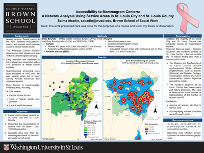
Low Income Housing Tax Credit Properties in St. Louis City and St. Louis County
Ross Clark and Nina Parikh
12-1-2012This project aims to identify areas that have a large concentration of LIHTC properties and what areas are most in need of LIHTC properties. Where are the areas most at risk of losing affordable housing due to LIHTC properties approaching Year 15?
-

Needs Assessment: Saint Louis After School Programs
Daniel Sherling and Holly Warth
12-1-2012This project examines correlation between St. Louis areas with high crime rates, large school-aged population and access to after school programs.
-

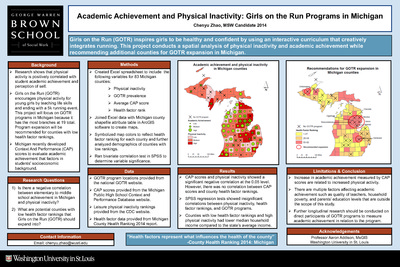
Positive Youth Development: Opportunity and Access
Anna Gennari
7-9-2012The goals of this project include contributing to the on-going Regional Initiative on Youth Resource Directory, identifying potential gaps in Youth Development services based on program location and total youth population, and informing future place-based research and public policy.
-

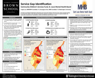
Potential for Small African-American Owned Businesses in the St. Louis Region: An Alternative Approach to Assessing Communities with the DrillDown Report
Alicia Ajayi
7-9-2012This project aims to identify block groups that have a stable economic environment with a significant African-American population and to identify industry gaps for small business owners.