

Course description: This course will familiarize students with the basic knowledge of geographic information systems (GIS) and their application to social work practice and research. The course is organized around three primary areas: 1) conceptual; 2) technical; and 3) data management. A conceptual overview of GIS is presented to provide students with foundational knowledge about the theory, purpose, function, and applicability of GIS in practice and research settings. Students will develop critical thinking skills necessary to devise research questions appropriate for a GIS, to develop a GIS, interpret the findings, and to evaluate the spatial relationships between variables.
-

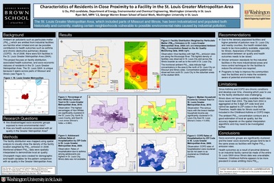
Do Vacant Land Improvement Efforts Affect Crime Rates?
Breann Schubert
12-1-2013This project examines how are St. Louis City vacant land improvement efforts affecting nearby crime rates.
-

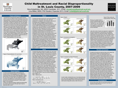
Encouraging Economic Development in the City of Maryland Heights
Cynthia De La Torre
5-7-2013This project asks if the current minimum area threshold for Planned Districts is effective in encouraging the development of commercial, industrial, and residential parcels.
-
 Luo")
Epidemiological Distribution of Stomach Cancer Using Geographic Information Systems: Worldwide, Asian, and US Asians
Susu (Ting) Luo
5-7-2013This project asks the following questions: what is the epidemiological distribution of the age-world-standardized incidence rates of stomach cancer in each country? What is the epidemiological distribution of the age-adjusted incidence rates of stomach cancer in each state across the United States? Is there race disparity of incidence rate of stomach cancer in the United States?
-

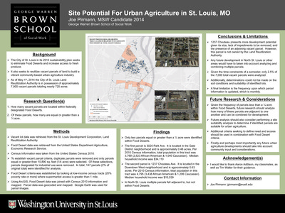
Expanding Farmers’ Markets in St. Louis City and County
Alyssa Tutterow
7-1-2013This project asks the following questions: what are the typical neighborhood characteristics in farmers’ market locations? Where could an additional farmers’ market be located in order to serve the community and be a successful business?
-

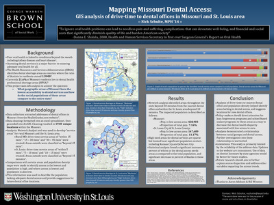
Flood Plain Demographics Surrounding St. Louis, Missouri
Caroline Olstad
12-1-2013The aim of this project is to determine how many people are living in a 100-year flood plain in the St. Louis, Missouri region and to determine the racial and socioeconomic demographics of people living in a 100-year flood plain to target flood preparedness interventions.
-

Higher Education Attainment of National Guard Members Post-Deployment
Stephanie Nune and Carissa van den Berk-Clark
12-1-2013This porjet seeks to answer the following question: among the group of National Guard veterans from the Midwest region returning from deployment what indicators (environmental, societal, and demographical) will predict who is most likely to attend a higher education institution?
-

High Risk Areas for Human Sex Trafficking Activity In Southwestern Illinois
Ambar Plasencia
12-2013Human trafficking is often explained as “modern‐day slavery”. It involves the forced exploitation of a person for a service. Through research and close analysis of case studies, experts have been able to identify salient risk factors that tend to increase the risk of human trafficking activities.
The aim of this project is to identify potential areas of high risks for human sex trafficking in southwestern Illinois, in hopes of better equipping law enforcement and social service agencies in combatting sex trafficking.
Located businesses associated with a high base risk for trafficking activities,and identified clusters of these within a 0.5 mile radius from any state road or interstate highway.
-

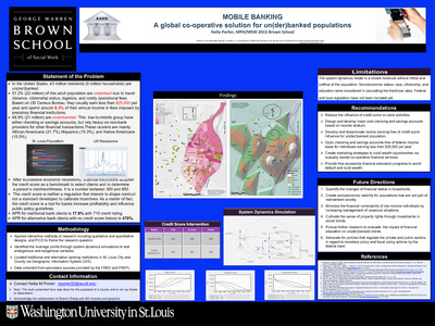
Identifying Relationships Between Anchor Institutions and Socioeconomic Indicators in the Mississippi Delta
Brandon Farber
12-1-2013This project seeks to identify relationships between the location of anchor institutions and the poverty and unemployment rates in the corresponding census tracts.And advance knowledge to more adequately leverage the resources and influence of anchor institutions.
-

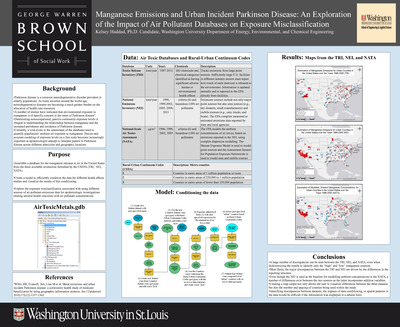
Integration of Dispersion Modeling with Spatial Interpolation of Measured Air Pollutant Concentrations
Stephen Feinberg
12-1-2013This project aims to develop and evaluate an alternate exposure estimation tool to improve on normal IDW interpolation, compare the new method with IDW interpolation to evaluate potential improvements.
-

Interrogating Birth Defects in Missouri using GIS
Monami Majumder and Rikki Sitzes
12-1-2013This project seeks to discover any difference in birth defects by dietary intake and environmental exposure, assess if there is any difference in birth defects by economic status, and pßropose necessary actions for authorized agencies to alleviate the increasing trend of birth defects in Missouri based on our findings.
-

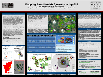
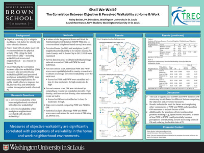
Mapping Barriers to Accessibility: Identifying priority communities for public transit advocacy
Ellis Ballard
7-1-2013This project asks if St. Louis’ bus network is accessible to people with disabilities and, if not, which communities should be prioritized for community-based organizing and advocacy for accessibility improvements
-

Mapping the Youth Control Complex: Or, the failure of large scale surveys
Masha Serdyukova
5-7-2013This project studies the quesiton of how the YCC impacts urban youth compared to suburban and rural.
-

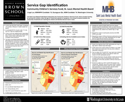
Meeting the Hispanic/Latino Mental Health Needs in the City of St. Louis
Ana Vargas
7-1-2013This project seeks to identify mental health risk factors for the Hispanic/Latino population, locate current bilingual mental health services in St. Louis, and conduct an analysis on areas with large Hispanic population growth and low medium household income in relation to identified mental health services.
-

Neighborhood Churning in St. Louis City
Sami Kordonowy
7-1-2013This project seeks to discover a correlation between the different reasons people move and where they are moving to in St. Louis and to find a way to measure neighborhood churning.
-

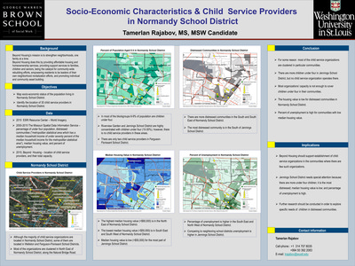
Neighborhood Factors and Educational Outcomes at High Schools in St. Louis
Moo-Hyun Kim
5-7-2013This project asks the following questions: what are the demographic characteristics of St. Louis City and County in terms of racial/ethnic compositions? Do neighborhoods with concentrated poverty levels have high rates of minority population? Are the levels of concentrated poverty of neighborhoods related to the educational outcomes of public high schools in the neighborhoods?