

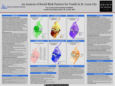
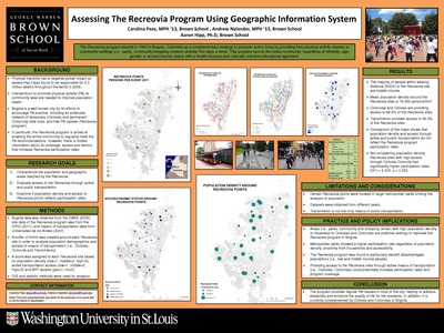
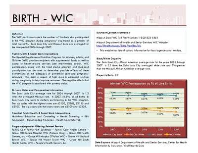
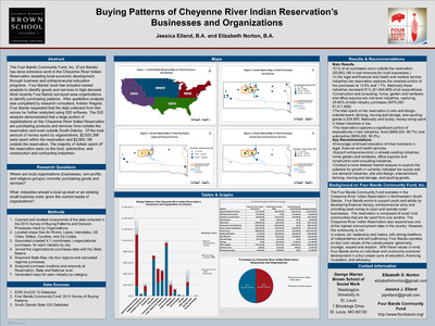
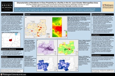
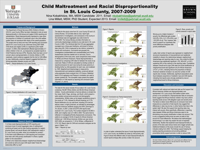
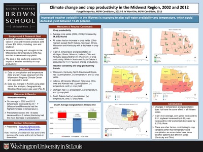
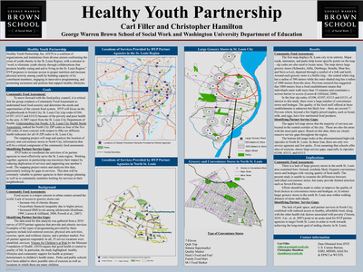
Course description: This course will familiarize students with the basic knowledge of geographic information systems (GIS) and their application to social work practice and research. The course is organized around three primary areas: 1) conceptual; 2) technical; and 3) data management. A conceptual overview of GIS is presented to provide students with foundational knowledge about the theory, purpose, function, and applicability of GIS in practice and research settings. Students will develop critical thinking skills necessary to devise research questions appropriate for a GIS, to develop a GIS, interpret the findings, and to evaluate the spatial relationships between variables.
-

Recommendation Sites for New ADAP Pharmacy in Washington D.C
Lina Cai
7-9-2012This project aims to understand demographic factors of people who living with HIV/AIDS in the level of census tract in D.C., analyze locations and accessibility of ADAP pharmacies, and provide recommendations for new pharmacy locations.
-

Shared Responsibility: The Solution to Water Quality and Flooding Problems in Missouri Senate District 14
Mary Ann Merz and Neeraja Ganeshraj
12-1-2012This project seeks to educate residents about factors contributing to the frequency and level of floods and their impact on public health.
-

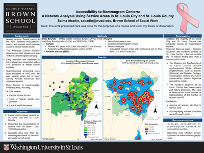
St. Louis City Public Parks: Access, Income, and Population Density
Genny Spernoga
7-9-2012This project aims to study the following questions: does park access vary according to income? Do census tract areas with household income above the median have more park area than census tracts with household income below the median? Where are the parks in relation to the population? Are there areas of high density population without park land?
-

The Impact of Agricultural Risk in Rajasthan, India
Jessica Londeree and Komal Nadkarni
12-1-2012This project aims to identify regions in the state of Rajasthan with the highest agricultural risk and to illustrate the potential outcome of this agricultural risk on human health and rates of rural-to-urban migration.
-

The McKinney Vento Act: Keeping Kids In Designated Schools
Alex Sullivan
7-9-2012This project aims to answer the question of what the most effective way to ensure that school districts adhere to the Mckinney-Vento requirements in order to gurantee that homeless children attend school on a regular basis is.
-

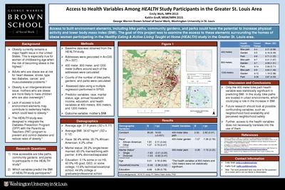
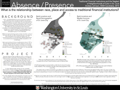
Understanding Barriers to Bank Branch Access for the Poor in St. Louis
Anthony Molieri
7-9-2012This project asks the question of whether or not areas within the City of St. Louis with a high percentage of people living in poverty have access to traditional financial services.
-

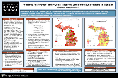
U.S. Indoor Tanning Policy and Melanoma
Mary Wang and Mira Yoon
12-9-2012Melanoma is the most dangerous type of skin cancer and causes the most deaths from skin disease in the U.S. The objective of this project is to examine differences in melanoma rates between states with different levels of regulation on indoor tanning.
-
 distribution across Nepal by Katherine Williams and Parmeshwar Narayan Amatya")
Water, Sanitation & Hygiene (WASH) distribution across Nepal
Katherine Williams and Parmeshwar Narayan Amatya
12-1-2012This project examines the current distribution of sanitation facilities across Nepal and whether there are significant disparities in each of these between the country’s five development regions.
-

Weathering the Recession: Economic Impact ofBeyond Housing’s Work in Pagedale and the 24:1 Municipalities
Josh Jennemann and Lauren Samuelson
12-1-2012This project analyzes the impacts of SERH on the economic vitality of the 24:1 Initiative area, particularly Pagedale, over the 8 years preceding.
-

Determining Brothel Districts as Households and Neighborhoods
Mark Pham
12-1-2011This project attepts to fully understand the industries of commercial sex and traffcking and explores the household and neighborhood dynamic of girls at risk for exploitation.
-

Ex Offender Resources in St. Louis City
Miranda Root
12-1-2011This project compares the placement of ex offender programs to the location of the ex offender population in St. Louis City. To observe the number of agencies providing ex offender specific services, the types of services, and their locations
-

Income Poverty and Access to State Subsidized Childcare Facilities
Amanda Blount
12-1-2011This project examines descriptive analysis of access to State subsidized childcare facilities for families in North St. Louis who have preschool aged children living under the poverty line.
-

Land Use& Rubber Plantation in Jinghong County, Yunnan, China
Manrui Zhang
12-1-2011Using spatial-temporal analysis this project explores the change of land use and trend of rubber plantation between 2002 to 2008 in Jinghong County, Yunnan Province.
-

Medical Resupply Point for Medical Centers in the Artibonite Region of Haiti
Michael Hur
12-1-2011By measuring factors such as transport costs based on distance, this project aimed to determine optimal medical resupply point for Medical Centers in the Artibonite Region of Haiti.
-

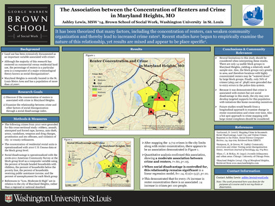
Physical Disorder and Crime: The Ville Neighborhood in St. Louis City, Missouri
Ashley Hearn
12-1-2011Using Google Earth Street View to evaluate neighborhood conditions, this project investigates the relationship between physical disorder and crime in The Ville neighborhood of St. Louis, MO.