

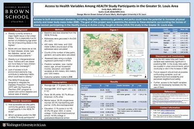
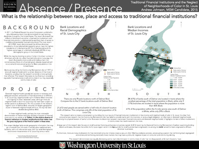
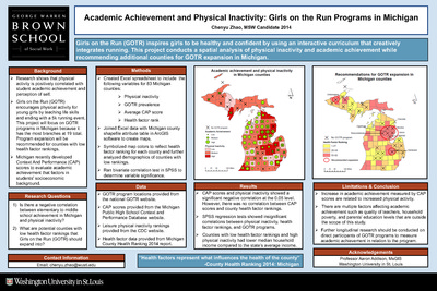
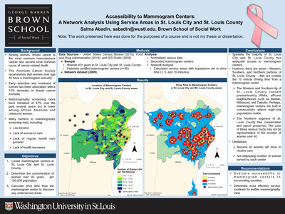
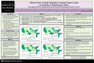
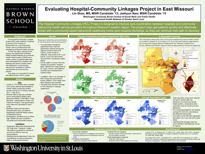
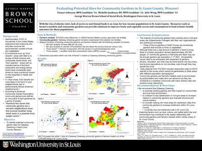
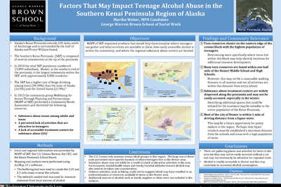
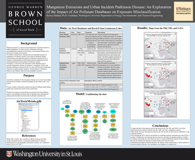
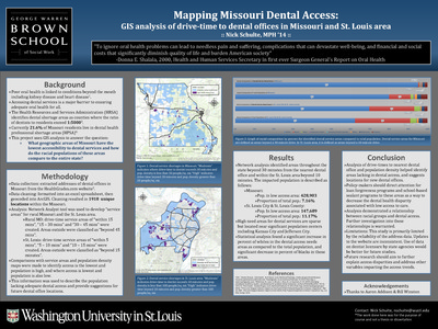
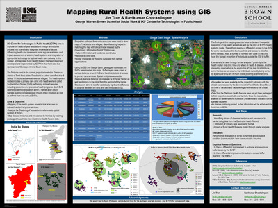
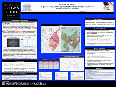
Course description: This course will familiarize students with the basic knowledge of geographic information systems (GIS) and their application to social work practice and research. The course is organized around three primary areas: 1) conceptual; 2) technical; and 3) data management. A conceptual overview of GIS is presented to provide students with foundational knowledge about the theory, purpose, function, and applicability of GIS in practice and research settings. Students will develop critical thinking skills necessary to devise research questions appropriate for a GIS, to develop a GIS, interpret the findings, and to evaluate the spatial relationships between variables.
-

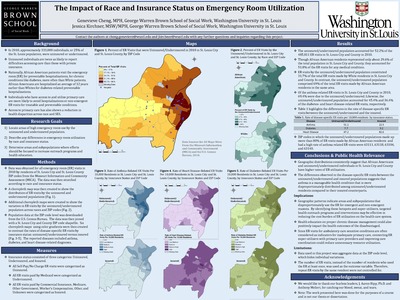
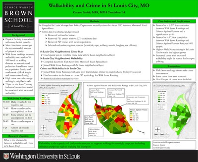
Walkability and Crime in St Louis City, MO
Carson Smith
5-4-2014This project looks at the correlation between walkability and crime in St Louis City.
-

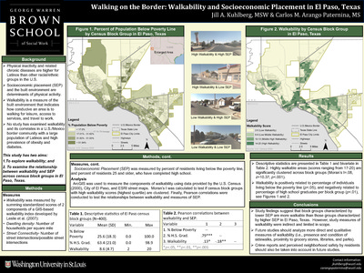
Walking on the Border: Walkability and Socioeconomic Placement in El Paso, Texas
Jill A. Kuhlberg and Carlos M. Arango Paternina
12-12-2014This study has two aims: To explore walkability; andTo examine the relationship between walkability and SEP across census block groups in El Paso, Texas. Physical inactivity and related chronic diseases are higher for Latinos than other racial/ethnic groups in the U.S. Socioeconomic placement (SEP) and the built environment are determinants of physical activity. Walkability is a measure of the built environment that indicates how conducive an area is to walking for leisure, access to services, and travel to work. No study has examined walkability and its correlates in a U.S./Mexico border community with a large population of Latinos and high prevalence of obesity and diabetes.
-

Watering the Food Deserts: Revisiting the SNAP Policy in South Texas
Laura Sandoval
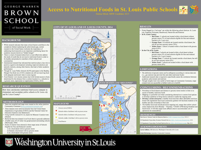
12-9-2014Food deserts are defined as either urban or rural neighborhoods or towns lacking access to fresh, healthy, and affordable food. The Rio Grande Valley region of Texas along the U.S.-Mexico border is comprised of approximately 400,000 people, 86% of them Hispanic. Nearly 40% of the residents of the Rio Grande Valley receive assistance through the Supplemental Nutrition Assistance Program (SNAP). Hidalgo County in the Rio Grande Valley is among the 10 poorest counties in the country. Due to a demand for low-cost housing in this area, more than 2,000 colonias have boomed. Colonias are considered rural Mexican-origin settlements often lacking basics such as paved roads, streetlights, and running water. Hidalgo county has one of the highest populations of colonias. Food insecurity is a major concern for the residents of South Texas. While there are plenty of convenience stores and mobile food vendors contributing to the snacking habits of the Hispanic population, only 30% of the items sold are nutritious fruits and vegetables. This project asks where are the retailers accepting SNAP benefits in Weslaco, Texas within Hidalgo County in South Texas, and based on that where are potential locations providing access to healthier foods? How can the SNAP policy be improved to better serve Hidalgo County in South Texas?
-

Welcoming Missouri Project
Yeongsil Kwon and Eun Young Lee
12-12-2014Racial profiling (Missouri Attorney General, n. d.) Missouri Attorney General Office (AGO) conducts survey of vehicle stops to highlight and combat racial profiling in the state, requiring all police departments to document a driver’s race for each vehicle stop. This project team hypothesizes that counties with a lower DI have more friendly environments towards Hispanic and Asian immigrants than counties with a higher DI. This project examined the association between residential immigrant concentration and racial profiling in the community. Combining the goal of MIRA and racial profiling occurring in MO, specific regions were selected where WMI is needed the most as well as where it is most adequately available.
-

Where is Hope Moving in? A Geospatial Analysis of a St. Louis City Homelessness Prevention Program
Mary Hegel and Hena Banerjee
12-12-2014The American Recovery and Reinvestment Act of 2009 funded the Department of Housing and Urban Development’s (HUD) Homelessness Prevention and Rapid Re-housing Program (HPRP). HPRP funds $8.1 million of the $8.4 million budget of St. Louis City’s Hope Is Moving In Initiative (HIMI). The City subgranted HIMI funds to four homelessness prevention service providers, who operated in four zones that were designated by city political boundaries (wards). This study is concerned with the funding for homelessness prevention services allocated to agencies serving the NE, NW, SE, SW regions of St. Louis City.
-

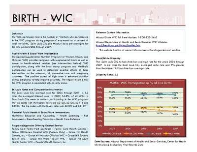
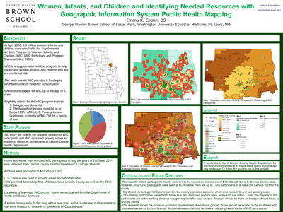
Women, Infants, and Children and Identifying Needed Resources with Geographic Information System Public Health Mapping
Emma K. Epplin
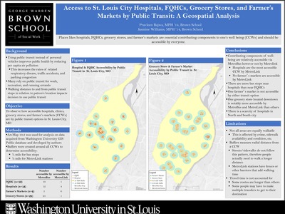
12-12-2014This study will look at the physical location of WIC participants and WIC approved grocery stores in relation to distance, and income at Lincoln County Health Department.
-

Analyzing Reported Calls and Arrests in Twin Lakes & Coyote Canyon, New Mexico on Battery Crime
Lindsay Belone
5-7-2013This project seeks to compare two communities on the Navajo reservation in New Mexico to examine battery crime cases reported and arrests for battery offenders.
-

Assessing the Implementation of NREGS in India and Potential Areas to Expand
Bambry Xiao
12-1-2013The aim of this project is to evaluate the program implementation on district level and detect the districts that have the potential to expand the program as well as to answer the questions of what the geographic variance of performance within the state is and what the geographic variance of performance over the country is.
-

Assessing the St. Louis County Flood Plain: An Exploration of the Lemay Community
Velvet E. Bryant
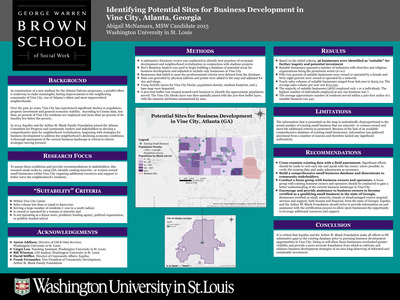
7-1-2013This project examines how the local economy and community recovered from the 1993 flood through the replacement or expansion of residential and commercial property values. It asks: what support services and factors facilitate small business development in Lemay and St. Louis County more broadly?
-

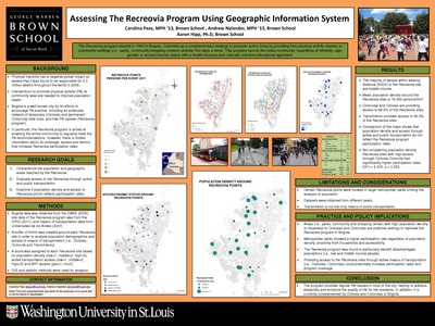
A Walk in the Park: Extent and Distribution of the Parks and Recreation Facilities Supported by the Municipal Park Grant Commission of St. Louis County
Christine O'neil
5-7-2013This project investigates how many individuals live within walking distance (0.5 miles) of a Commission-funded project, how many of these individuals are children or youth below the age of 18, if the communities in the immediate vicinity of Commission-funded projects are demographically similar to St. Louis County as a whole, and specific demographic factors to be analyzed include age, race, and median household income.
-

Broadband Internet Availability and Accessibility in the State of Missouri
Anjila Prasai
12-1-2013The goal of this project is to identify areas in the state of MO where broadband internet services are available. Locate public libraries in the state of MO with broadband internet accessibility, rank Missouri counties based on high poverty, low educational attainment, and high unemployment rate, and identify any correlation with high speed internet availability and accessibility.
-

Childhood Asthma, Healthcare access, and the Urban Neighborhood in St. Louis, Missouri
Kelly Harris
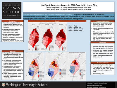
12-1-2013The purpose of this study is to identify ‘hotspots’ or concentrations of increased childhood asthma prevalence within the city of St. Louis, and examine the neighborhood characteristics and access to healthcare resources within these hotspots to identify relevant patterns or correlations
-

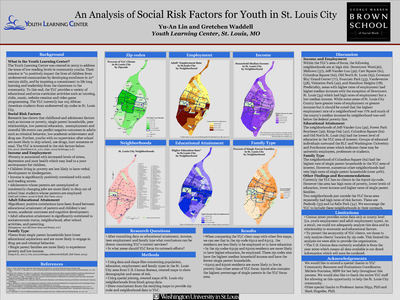
Community-Level Factors and High School Graduation Rates for Youth with Sickle Cell Disease
Barbara Ddamulira
5-7-2013This project explores what community level factors impact high school graduation rates in youth with SCD.
-

Crime and Refugee Disparity in St. Louis
Andrew Sheeley
7-1-2013The aim of this project is to determine the degree of spatial separation between European and Non-European refugees and to measure the degree to which refugees in St. Louis City are exposed to crime as opposed to those residing in St. Louis County.
-

Demographic Variations in Greenway Users and Nearby Residents on aNewly Constructed St. Louis GreenwayDemographic Variations in Greenway Users and Nearby Residents on aNewly Constructed St. Louis Greenway
Marissa Zwald
5-7-2013This project seeks to examine the demographic characteristics of greenway users on a newly constructed greenway in St. Louis, Missouri compared to the demographic profile of residents living in adjacent census blocks.