

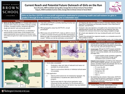
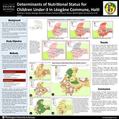
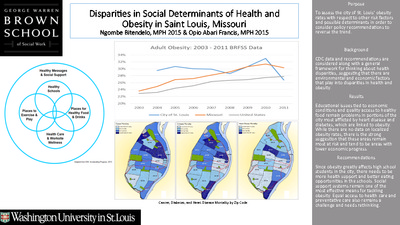
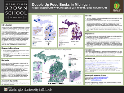
Course description: This course will familiarize students with the basic knowledge of geographic information systems (GIS) and their application to social work practice and research. The course is organized around three primary areas: 1) conceptual; 2) technical; and 3) data management. A conceptual overview of GIS is presented to provide students with foundational knowledge about the theory, purpose, function, and applicability of GIS in practice and research settings. Students will develop critical thinking skills necessary to devise research questions appropriate for a GIS, to develop a GIS, interpret the findings, and to evaluate the spatial relationships between variables.
-

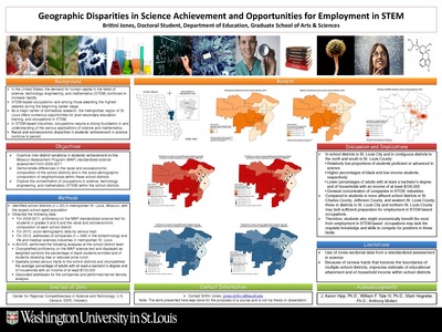
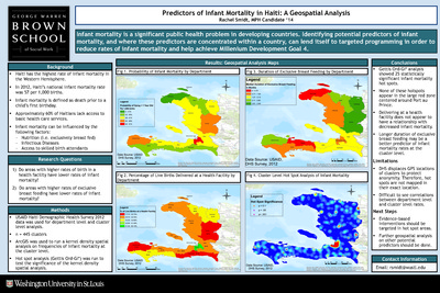
Predictors of Infant Mortality in Haiti: A Geospatial Analysis
Rachel Smidt
5-4-2014This project examines whether areas with higher rates of birth in a health facility have lower rates of infant mortality.
-

Produce Accessibility and Community Health in the Old North St. Louis and Shaw Neighborhoods
E. Gracie Aeschbacher
6-30-2014In light of the recent grocery store closings around Old North St. Louis, the project asks where the alternative sources of produce in the area are, how accessible those sources are, how the North City and Tower Grove Farmers’ Markets impact produce accessibility in the surrounding communities, and if produce accessibility is reflected in other aspects of the neighborhoods, such as health outcomes.
-

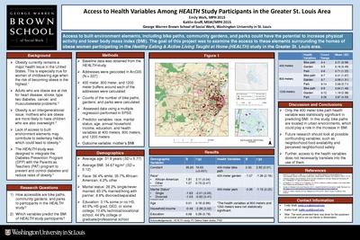
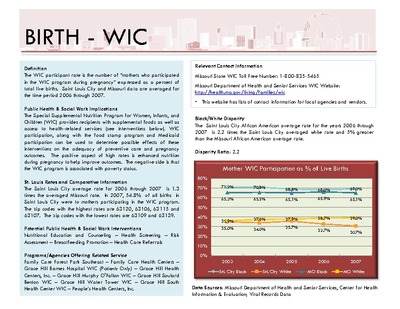
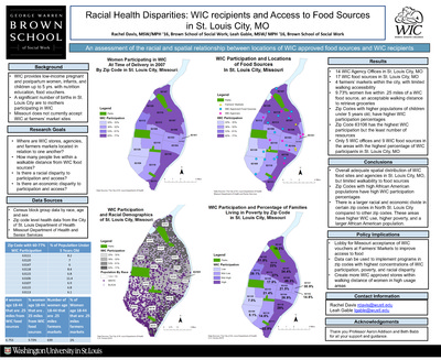
Racial Health Disparities: WIC recipients and Access to Food Sources in St. Louis City, MO
Rachel Davis and Leah Gable
6-30-2014This project aims to identify where WIC stores, agencies, and farmers markets are located and show the relationship between them as well as walkabillity to WIC food sources. The project also seeks to explore correlation between racial or economic disparity to participation and access.
-

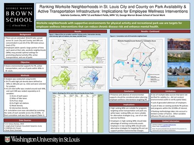
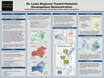
Ranking Worksite Neighborhoods in St. Louis City and County on Park Availability & Active Transportation Infrastructure: Implications for Employee Wellness Interventions
Gabriella Camberos and Robert Fields
12-12-2014There are an estimated 816,672 jobs spread across St. Louis City and County, and 34% are concentrated in just 24 of the 305 total census tracts (CTs). Employed adults spend a large portion of time each week at their jobs, worksite neighborhoods (WNs) may provide optimal settings for promoting physical activity (PA), active transportation, and use of parks. This poster examines worksite neighborhoods with supportive environments for physical activity and recreational park use are targets for employee wellness interventions that can reduce chronic disease risk and enhance mental health.
-

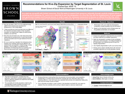
Recommendations for Kiva Zip Expansion by Target Segmentation of St. Louis
Chelsea Dyer
12-9-2014As a start-up non-profit with limited resources, Kiva Zip seeks to expand their presence nationally through carefully targeted efforts in marketing and fundraising. St. Louis is on a short-list to earn the designation of a Kiva Zip City with the establishment of local support from government leaders and financial donors. In order to gain the necessary momentum to become an official Kiva Zip City, which results in on-the-ground support and matched loans from sponsors, St. Louis must prove itself as a source of successful borrowers. This project asks what areas in St. Louis match the demographic composition of past successful Kiva Zip borrowers, and from this which of these areas has the greatest concentration of minorities?
-

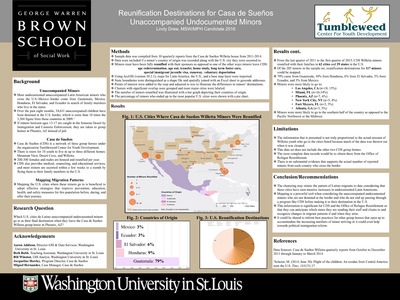
Reunification Destinations for Casa de Sueños Unaccompanied Undocumented Minors
Lindy Drew
6-30-2014This project examines which U.S. cities Latino unaccompanied undocumented minors go to as their final destination when they leave the Casa de Sueños Willetta group home in Phoenix, AZ.
-

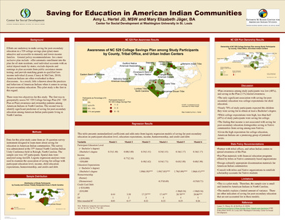
Saving for Education in American Indian Communities
Amy L. Hertel and Mary Elizabeth Jäger
12-12-2014Efforts are underway to make saving for post-secondary education in a 529 college savings plan (plan) more attractive and accessible to minority and lower-income families. There were two objectives for this pilot study. The first was to geospatially assess NC 529 College Savings Plan (NC 529 Plan or Plan) awareness and ownership patterns among American Indians in North Carolina. The second was to identify significant predictors of saving for post-secondary education among American Indian participants living in North Carolina.
-

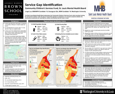
Service Gap Identification Community Children’s Services Fund, St. Louis Mental Health Board
Lingzi Luo and Guangyuan Qui
6-30-2014This project examines to what extent the CCSF is serving children residing in the most in need geographic areas using GIS the project idenitifes geographic areas that need more investment, especially for racial or ethnic minority groups (e.g., African Americans).
-

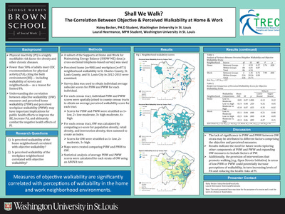
Shall We Walk? The Correlation Between Objective & Perceived Walkability at Home & Work
Haley Becker and Laural Heermance
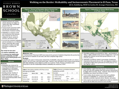
12-12-2014Physical inactivity (PI) is a highly modifiable risk factor for obesity and other chronic diseases. Fewer than 50% of adults meet CDC recommendations for physical activity (PA), citing the built environment (BE)— including walkability of streets and neighborhoods— as a reason for limited PA. Understanding the correlation between objective walkability (OW) measures and perceived home walkability (PHW) and perceived workplace walkability (PWW) may have important implications for public health efforts to improve the BE, increase PA, and ultimately combat the negative health effects of PI. This project asks is perceived walkability of the home neighborhood correlated with objective walkability? Is perceived walkability of the workplace neighborhood correlated with objective walkability?
-

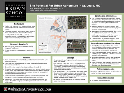
Site Potential for Urban Agriculture in St. Louis, Mo
Joe Pirmann
5-4-2014This project explores how many vacant parcels are located within federally designated Food Deserts and asks of these parcels, how many are equal or greater than a 1/4 acre.
-

Social Determinants of Readmissions to BJC HealthCare Hospitals
Yeon Jin Choi and Thuy-Linh Nguyen
12-12-2014This poster shows neighborhood level social determinants of health were explored for its potential relationship with 30-day all-cause readmission among Medicare patients 65 years of age and older who were originally admitted for acute myocardial infarction (AMI), congestive heart failure (CHF), and community acquired pneumonia (CAP) in 2010 at a hospital within the BJC HealthCare network.
-

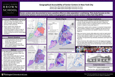
Social Exclusion among Older Adults in St. Louis: A GIS Analysis
Yu-Chih Chen and Amensissa Edossa
12-12-2014Social exclusion is a dynamic process that describes an individual being fully or partially blocked from various rights, opportunities, or resources Many studies use older adults’ poverty as a proxy to measure social exclusion among older adults Although studies revealed that older adults are more vulnerable to be socially excluded, most studies of social exclusion focus on the children and families; this creates a niche for under-standing the social exclusion among older adults. In addition, most studies focus on the cumulative disadvantages (e.g. poverty) among older adults while recently research showed that the key to help the elderly to be socially included should examine the community factors and barriers For example, senior centers are documented to have a positive effect for older adults while negative community profiles are detrimental to their well-being This study aims to examined the association between social exclusion and community factors among elderly by using GIS approach.
-

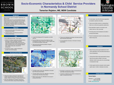
Socio-Economic Characteristics & Child Service Providers in Normandy School District
Tamerlan Rajabov
12-12-2014Beyond Housing’s mission is to strengthen neighborhoods, one family at a time. Beyond Housing does this by providing affordable housing and homeownership services, providing support services to families, children and seniors, being the catalyst for community-wide rebuilding efforts, empowering residents to be leaders of their own neighborhood revitalization efforts, and promoting individual and community asset building.
-

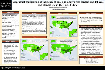
Solid Fuel Use in the Philippines: An Exploratory Sociospatial Analysis
Lisa Reyes Mason
12-12-2014Over two billion people worldwide use solid fuels (e.g., charcoal, wood, crop waste) for cooking, lighting, and other basic needs. When used with traditional cooking methods, solid fuels contribute to indoor air pollution and threaten maternal and child health (Rehfuess, Mehta, & Prüss-Üstün, 2006; UNDP, 2008). In the Philippines, 65% of households report solid fuels as their main source of cooking energy (NSO & ICF Macro, 2009). This study uses spatial analysis and multilevel modeling to explore two questions: are there spatial differences in household solid fuel use (HSFU) in the Philippines? What social, economic, and geographic characteristics are associated with such use?
-

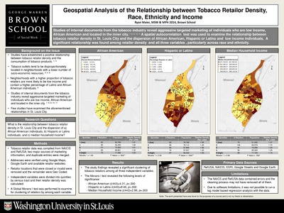
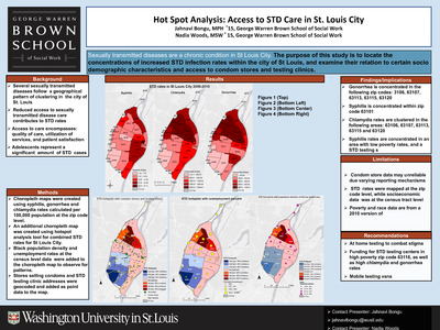
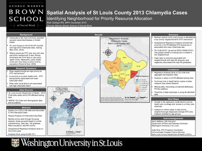
Spatial Analysis of St. Louis County 2013 Chlamydia Cases Identifying Neighborhood for Priority Resource Allocation
Ruth Gallego
6-30-2014This project examines what neighborhoods are high priority for STD interventions, asks if proximity to a public health clinic/STD testing facility is associated with lower chlamydia rates, and asks what other social factors are associated with high chlamydia rates.