

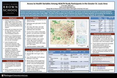
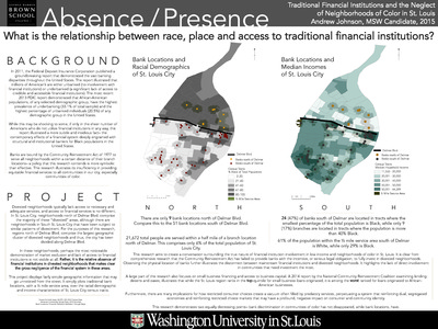
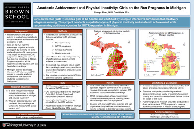
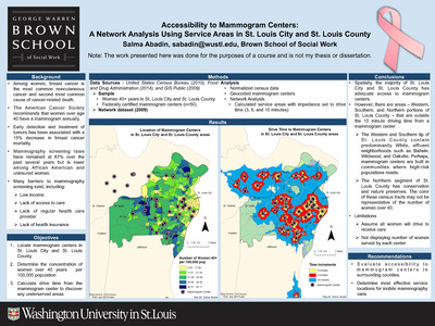
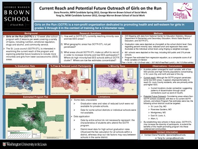
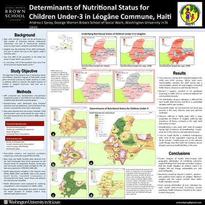
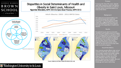
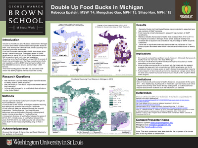
Course description: This course will familiarize students with the basic knowledge of geographic information systems (GIS) and their application to social work practice and research. The course is organized around three primary areas: 1) conceptual; 2) technical; and 3) data management. A conceptual overview of GIS is presented to provide students with foundational knowledge about the theory, purpose, function, and applicability of GIS in practice and research settings. Students will develop critical thinking skills necessary to devise research questions appropriate for a GIS, to develop a GIS, interpret the findings, and to evaluate the spatial relationships between variables.
-

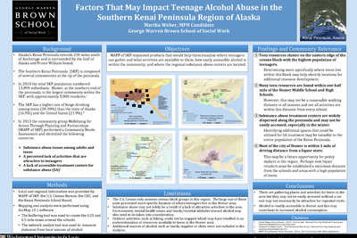
Factors That May Impact Teenage Alcohol Abuse in the Southern Kenai Peninsula Region of Alaska
Martha Weber
5-4-2014This project examines MAPP of SKP requested products that would help them visualize where teenagers can gather and what activities are available to them, how easily accessible alcohol is within the community, and where the regional substance abuse centers are located.
-

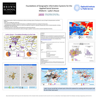
Foundations of Geographic Information Systems for the Applied Social Sciences Midterm: Lydia’s House
Peg Allen, David Ansong, Joanna Cohen, and Marsela Dauti
12-12-2014Lydia's House works in faith to end domestic violence, by being a place of healing and a voice of hope for abused women and their children. The organization wants to track the location of their supporters, to see change over time in the location of their donors, and if this difference over time varies by type of donor and donation source. This poster describes the GIS analysis used to assist them in focusing future resource development efforts.
-

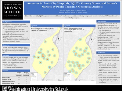
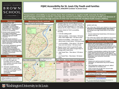
FQHC Accessibility for St. Louis City Youth and Families
Philip Horn
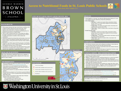
5-4-2014This project aims to discover which FQHCs in the St. Louis City region are accessible, taking crime statistics and public transit stops into account and to determine classifications of need for each St. Louis Public K-8 School accounting for public transit time and FQHC accessibility.
-

Gang Movement in a Changing City: The Case of St. Louis’s Dark Side
Amanda Stoermer and Anna Ravindranath
12-12-2014St. Louis neighborhoods have experienced quite a bit of social and economic change in recent history, namely rapid depopulation, a decline in the city’s industrial base, aging housing stock, and chronic unemployment (Decker & Van Winkle, 1996). All of these had a direct effect on the increase in poverty levels among St. Louis city residents and subsequently the rise in violent crime and gang activity (Decker & Van Winkle, 1996). Over time, pockets of crime and poverty, such as McRee Town, became eye sores to city officials and middle-class residents, and as a result large housing projects were demolished and more low-income neighborhoods began to see initiatives for development. This research project examines the effect the Botanical Heights development project had on the Dark Side gang by mapping the crime patterns of the gang during a span of nine years.
-

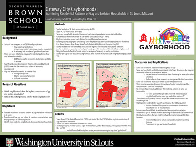
Gateway City Gayborhoods: Examining Residential Patterns of Gay and Lesbian Households in St. Louis, Missouri
Laurel Sariscsany and Samuel Taylor
6-30-2014This project aims to better understand residential patterns of gay and lesbian households in St. Louis. It asks how gay and lesbian St. Louisians construct urban space through analysis of community anchors and identifies most resided-in neighborhoods for gay and lesbian households.
-

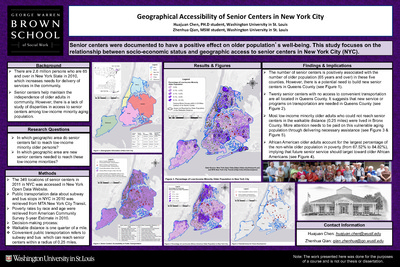
Geographical Accessibility of Senior Centers in New York City
Huanjuan Chen and Zhenhua Qian
12-12-2014Senior centers were documented to have a positive effect on older population’s well-being. This study focuses on the relationship between socio-economic status and geographic access to senior centers in New York City (NYC). There are 2.6 million persons who are 65 and over in New York State in 2010, which increases needs for delivery of services in the community. Senior centers help maintain the independence of older adults in community. However, there is a lack of study of disparities in access to senior centers among low-income minority aging population.
-

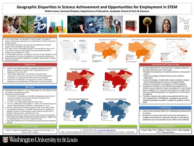
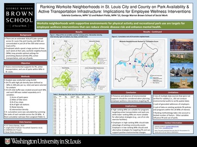
Geographic Disparities in Science Achievement and Opportunities for Employment in STEM
Brittni Jones
12-12-2014In the United States, the demand for human capital in the fields of science, technology, engineering, and mathematics (STEM) continues to increase rapidly. STEM-based As a major center of biomedical research, the metropolitan region of St. Louis offers numerous opportunities for post-secondary education, training, and occupations in STEM. The objectives of this study were to examine inter-district variations in students’ achievement on the Missouri Assessment Program (MAP) standardized science assessment from 2008-2011; demonstrate differences in the racial and socioeconomic composition of the school districts and in the socio-demographic composition of neighborhoods within these school districts; explore the concentration of occupations in science, technology, engineering, and mathematics (STEM) within the school districts
-

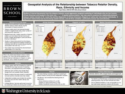
Geospatial Analysis of the Relationship between Tobacco Retailor Density, Race, Ethnicity and Income
Ryan Maier
5-4-2014This project examines the relationship between tobacco retailor density in St. Louis City and the dispersion of African American individuals, Hispanic or Latino individuals, and median household income.
-

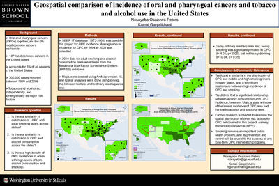
Geospatial comparison of incidence of oral and pharyngeal cancers and tobacco and alcohol use in the United States
Nosayaba Osazuwa-Peters and Kamal Ganjalikhani
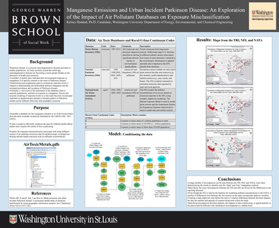
12-12-2014Oral and pharyngeal cancers (OPCs) together, are the 6th most common cancers worldwide Accounts for 3% of all cancers in the United States 13th most common cancers in the United States 300,000 cases reported between 1999 and 2008 Tobacco and alcohol act independently and synergistically as major risk factors. This project asks if there a similarity in distribution of OPC and adult smoking levels across states; is there a similarity in distribution of OPC and alcohol consumption across the states; is there a high density of OPC incidences in areas with high levels of both alcohol consumption and smoking.
-

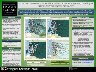
Hazardous Waste Generators: Social Justice Implications for King County, Washington
Christopher Fan and Marcella Gardner
12-12-2014Hazardous Waste Generators (LQGs) can be placed in almost any location, creating serious repercussions for residents around them. Hazardous waste carries severe health risks to humans, such as cancers, respiratory conditions, heart disease, neurobehavioral issues, liver and kidney damage, and many other health implications (CDC). This poster examines whether there is a correlation between locations of LQGs and race/ethnicity, income, and/or children in King County.
-

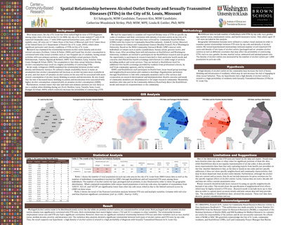
Healthy Food Availability for Low- Income Populations in Chicago, IL
Gwen Callaway
12-9-2014Fast food has become an inexpensive, convenient meal option to the tune of rising obesity rates. Accordingly, there are hundreds of locations in every major city – Chicago is no exception. But how does this compare to traditional sources of healthy food especially for low-income populations? This project aims to determine if a disparity exists in availability of healthy foods and if a disparity exists in availability of traditional fast food in Chicago, IL, as well as recommend a location for establishing a healthy food intervention.
-

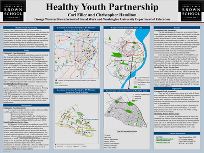
Healthy Youth Partnership
Carl Filler and Christopher Hamilton
12-12-2014Healthy Youth Partnership, Inc. (HYP) is a coalition of organizations and institutions from diverse sectors confronting the crisis of youth obesity in the St. Louis Region, with a mission to “work to eliminate youth obesity through collaborations that promote healthy eating and active living in the St. Louis Region.” The mapping project will map and analyze the location of grocery and convenience stores in North City, information that will be a critical component of the community food assessment.
-

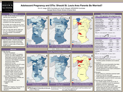
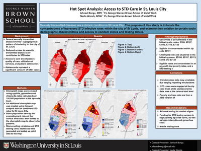
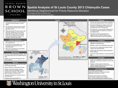
Hot Spot Analysis: Access to STD Care in St. Louis City
Jahnavi Bongu and Nadia Woods
12-12-2014This poster examines whether sexually transmitted diseases follow a geographical pattern of clustering in the city of St. Louis. Reduced access to sexually transmitted disease care contributes to STD rates. Access to care encompasses: quality of care, utilization of services, and patient satisfaction. Adolescents represent a significant amount of STD cases.
-

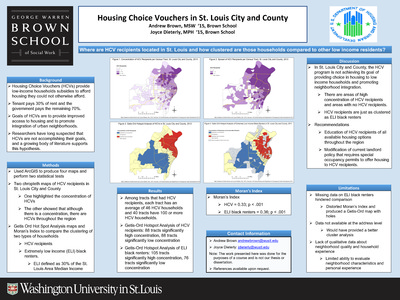
Housing Choice Vouchers in St. Louis City and County
Andrew Brown and Joyce Dieterly
12-12-2014Housing Choice Vouchers (HCVs) provide low-income households subsidies to afford housing they could not otherwise afford. Tenant pays 30% of rent and the government pays the remaining 70%. Goals of HCVs are to provide improved access to housing and to promote integration of urban neighborhoods. Researchers have long suspected that HCVs are not accomplishing their goals, and a growing body of literature supports this hypothesis. This poster examines where HCV recipients are located in St. Louis and how clustered those households are compared to other low income residents.
-

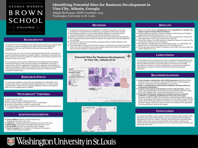
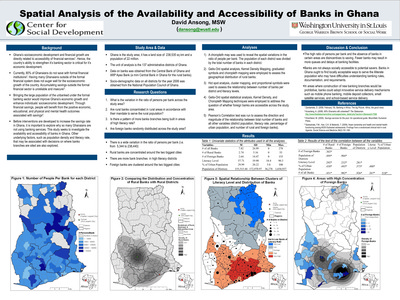
Identifying Potential Sites for Business Development in Vine City, Atlanta, Georgia
Abigail McNamara
12-9-2014As construction of a new stadium for the Atlanta Falcons progresses, a parallel effort is underway to make meaningful, lasting improvements to the neighboring community of Vine City, one of Atlanta’s oldest and most impoverished neighborhoods. Over the past 30 years, Vine City has experienced significant decline in population, property investment and general economic stability. According to Census data, less than 40 percent of Vine City residents are employed and more than 50 percent of its families live below the poverty. In 2014, Equifax and the Arthur M. Blank Family Foundation joined the Atlanta Committee for Progress and community leaders and stakeholders to develop a comprehensive plan for neighborhood revitalization, beginning with strategies for business development to address the neighborhood’s declining economic conditions. A thorough assessment of the current business landscape is critical to inform strategies moving forward. This research study seeks to, using GIS, identify existing minority- or women-owned small businesses within Vine City requiring additional resources and support tobetter serve the neighborhood’s residents.