

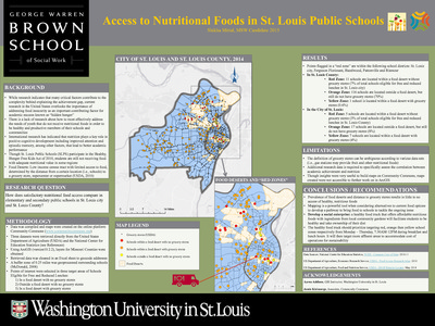
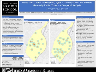
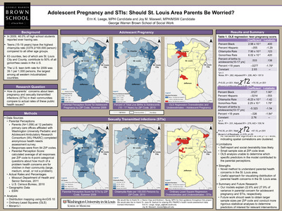
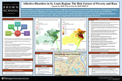
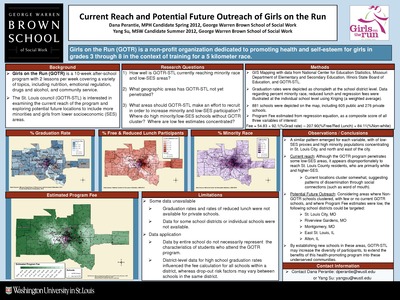
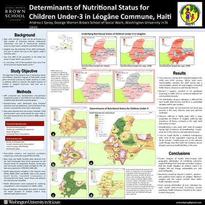
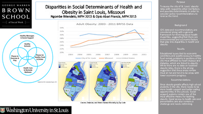
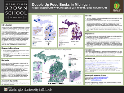
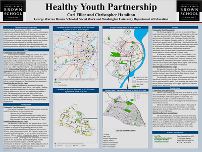
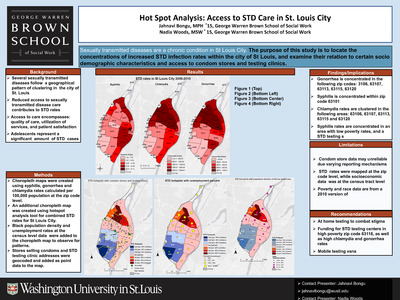
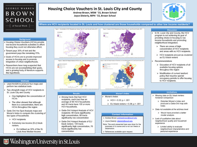
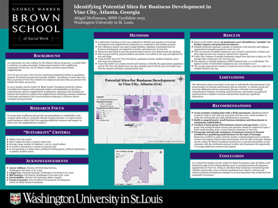
Course description: This course will familiarize students with the basic knowledge of geographic information systems (GIS) and their application to social work practice and research. The course is organized around three primary areas: 1) conceptual; 2) technical; and 3) data management. A conceptual overview of GIS is presented to provide students with foundational knowledge about the theory, purpose, function, and applicability of GIS in practice and research settings. Students will develop critical thinking skills necessary to devise research questions appropriate for a GIS, to develop a GIS, interpret the findings, and to evaluate the spatial relationships between variables.
-

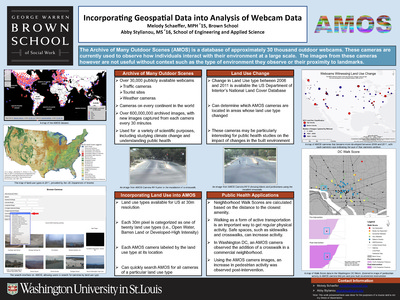
Incorporating Geospatial Data into Analysis of Webcam Data
Melody Schaeffer and Abby Stylianou
12-12-2014The Archive of Many Outdoor Scenes (AMOS) is a database of approximately 30 thousand outdoor webcams. These cameras are currently used to observe how individuals interact with their environment at a large scale. The images from these cameras however are not useful without context such as the type of environment they observe or their proximity to landmarks. This project aims to integrate spatial analysis with webcam data.
-
 and Food Deserts in Missouri, USA by Sharada Shantharam")
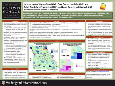
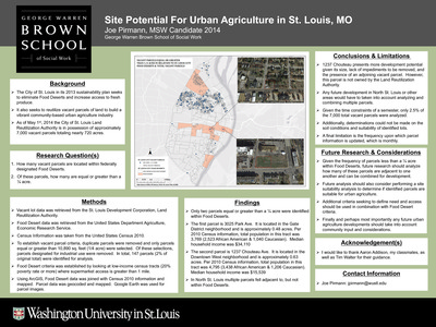
Intersection of Home-Based Child Care Centers and the Child and Adult Food Care Program (CACFP) and Food Deserts in Missouri, USA
Sharada Shantharam
12-9-2014Home-based child care centers are a prime location for the growth of a child. With the proper resources, they can improve child development, physically and cognitively. However, these resources are not always accessible, and thus adhering to regulations becomes difficult.
-

Investment and Disinvestment in College Hill Neighborhood
Elizabeth Thorne-Wallington and Yangyong Zhang
12-12-2014The College Hill project by Grace Hill focuses on developing the College Hill neighborhood. The mission of the project is to assert control over the area in order to improve it through resident ownership. Currently, there are new social service and health centers being developed by Grace Hill in the neighborhood, and the goal of the overall project is to change the entire nature of the neighborhood including the school system, retail services, and job centers. Grace Hill is hoping that the College Hill neighborhood will serve as a model of neighborhood cooperation that can then be emulated in other neighborhoods across the city. These maps work to answer what patterns exist in the neighborhood as well as where Grace Hill should focus its investment efforts.
-

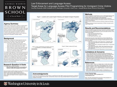
Law Enforcement and Language Access: Target Areas for Language Access Pilot Programming for Immigrant Crime Victims
Courtney Roelandts
12-12-2014Legal Services of Eastern Missouri (LSEM) is a nonprofit agency in St. Louis that is committed to providing high quality legal assistance to those who would otherwise be unable to obtain legal counsel. This project is intended for their Immigration Law Project, which assists clients at a variety of proceedings related to immigration status applications and petitions. LSEM most commonly works with immigrant victims of crime, for which the primary form of victimization is domestic violence.
-

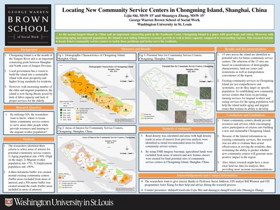
Locating New Community Service Centers in ChongmingIsland, Shanghai, China
Lijia Shi and Shuangyu Zhang
6-30-2014By utilizing GIS, this projects aims to identify potential locations for future community service centers. These centers could serve more elder people while providing resources and training to the migrant worker population.
-

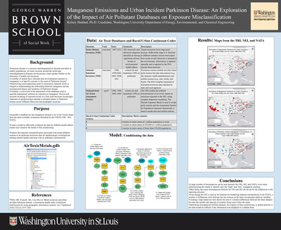
Manganese Emissions and Urban Incident Parkinson Disease: An Exploration of the Impact of Air Pollutant Databases on Exposure Misclassification
Kelsey Haddad
12-9-2014This project aims to assemble a database for the manganese releases to air in the United States from the three available inventories furnished by the USEPA (TRI, NEI, NATA) and to reate a model to efficiently condition the data for different health effects studies and visualize the results of this conditioning. The project will also explore the exposure misclassification associated with using different sources of air pollutant emissions data for epidemiologic investigations relating adverse health outcomes with air pollutant concentrations.
-

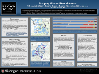
Mapping Missouri Dental Access: GIS Analysis of Drive-Time to Dental Offices in Missouri and St. Louis Area
Nick Schulte
5-4-2014This project examines what geographic areas of Missouri have the lowest accessibility to dental services and how do the racial populations of these areas compare to the entire state.
-

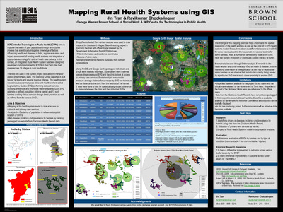
Mapping Rural Health Systems using GIS
Jin Tran and Ravikumar Chockalingam
12-12-2014IKP Centre for Technologies in Public Health (ICTPH) aims to improve the health of poor populations through an inclusive process that scientifically integrates knowledge of factors influencing health and diseases in India, regular evaluation and impact assessment of existing health systems and integration of appropriate technology for optimal health care delivery. In this context, an Integrated Rural Health System has been designed, developed and implemented by ICTPH in their field sites that spans across 15 villages in rural South India. This project includes mapping the health system model to look at access to outreach and primary care services, analyzing the clustering of population in reference to spatial location of SVG’ and mapping disease incidence and prevalence by hamlets by tracking geotagged households from Electronic Health Record data.
-

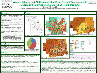
Mental Health and Offender Reentry in St. Louis
Rebecca Gernes and Sadie Pierce
12-12-2014This project examines the distribution and access to services for released offenders in the St. Louis metro area.
-
banked populations by Nella Porter")
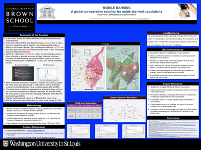
MOBILE BANKING: A global co-operative solution for un(der)banked populations
Nella Porter
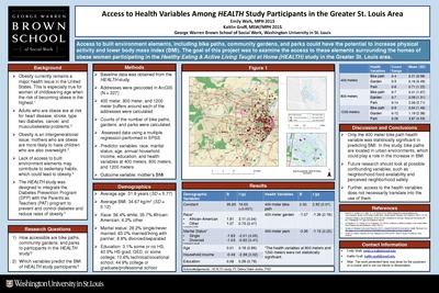
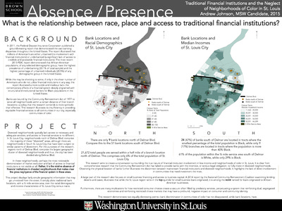
12-12-2014In the United States, 43 million residents (9 million households) are un(der) banked. 51.2% (22 million) of this adult population are unbanked due to travel distance, citizenship status, logistics, and costly operational fees. Based on US Census Bureau, they usually earn less than $25,000 per year and spend around 8.3% of their annual income in fees imposed by predatory financial institutions. 48.8% (21 million) are underbanked. This low-to-middle group have either checking or savings accounts, but rely heavy on non-bank providers for other financial transactions.These clusters are mainly African Americans (21.7%),Hispanics (19.3%), and Native Americans (15.5%). This project asks what are the risk factors of social exclusion among older adults in St. Louis? Where are the potential areas that older adults lived with higher levels of social exclusion? How and what kinds of intervention can be implemented in these areas?
-

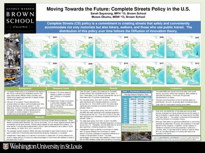
Moving Towards the Future: Complete Streets Policy in the U.S.
Sarah Sayavong and Moses Okumu
12-12-2014Complete Streets (CS) policy is a commitment to creating streets that safely and conveniently accommodate not only motorists but also bikers, walkers, and those who use public transit. The distribution of this policy over time follows the Diffusion of Innovation theory. This project aims to assess if CS policy adoption reflects a pattern consistent with diffusion of innovation theory; determine if modes of transport to work differ between stateswith CS policy differ and states without CS policy.
-
, Texas by Peg Allen, Christine Marx, and Christine M. Hoehner")
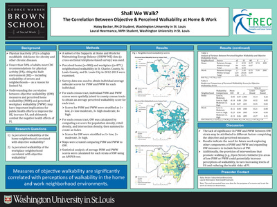
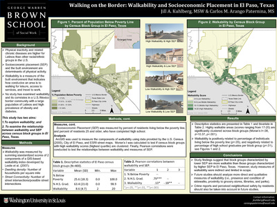
Neighborhood Land Use, Walking, and Cardiorespiratory Fitness among Cooper Clinic Participants in Travis County (Austin), Texas
Peg Allen, Christine Marx, and Christine M. Hoehner
12-12-2014This poster describes an attempt to test for associations of neighborhood land use with clinically measured cardiorespiratory fitness extended from previous research on built environment influences, which has relied mostly on self-reported physical activity. The organization wants to track the location of their supporters, to see change over time in the location of their donors, and if this difference over time varies by type of donor and donation source. GIS and such a report could assist them in focusing future resource development efforts.
-

Nurses For Newborns Foundation: Review of a Decade of Service
Amanda Maust and Kristen Siebels
12-12-2014Nurses for Newborns Foundation’s (NFN) mission is to provide a safety net for families most-at-risk by helping prevent infant mortality, child abuse and neglect through home-based programs that provide education, healthcare and positive parenting skills. How has NFN service area changed over the past 10 years in Missouri and Tennessee? This poject asks if there a relationship between NFN service areas in Missouri and Tennessee and the social indicators of health, including poverty level and educational attainment per ZIP code.
-

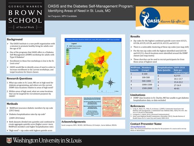
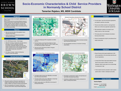
OASIS and the Diabetes Self-Management Program: Identifying Areas of Need in St. Louis, MO
Ian Ferguson
5-4-2014This project looks at what zip-codes in St. Louis, MO are in high need fordiabetes programming, and where are the current DSMP class locations relative to areas of high need.
-

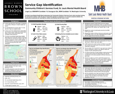
Operation Food Search: Feeding Children in Need
Hyunil Kim and Cecilia Zappa
12-12-2014Operation Food Search (OFS) is a nonprofit organization that provides food to individuals and families in need in 30 counties in the St. Louis region of Missouri and Illinois. The organization of OFS allows it to focus on establishing food networks, linking donors with partner agencies. OFS collects food from donors and distributes the food to partner agencies, who then distribute the food to people in need. In addition to the responsibility of managing efficient food networks, OFS operates the Hunger Hotline, where anyone can call the hotline to find out what resources are available to help with hunger in a given community This project asks which measurement of service delivery adequacy in each community is most useful in GIS to help OFS in its program evaluation? Which communities appear to be well served by OFS and its network partner agencies? Which communities are experiencing a service gap that OFS may want to consider trying to fill?