

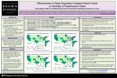
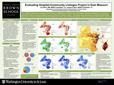
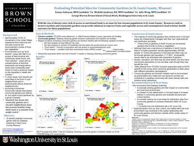
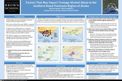
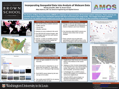
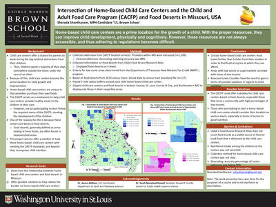
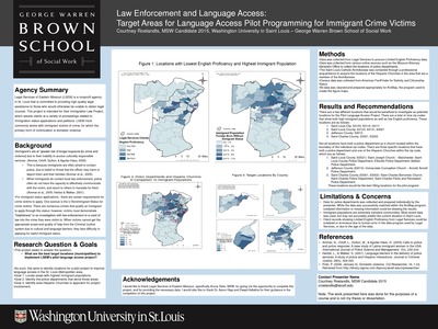
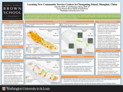
Course description: This course will familiarize students with the basic knowledge of geographic information systems (GIS) and their application to social work practice and research. The course is organized around three primary areas: 1) conceptual; 2) technical; and 3) data management. A conceptual overview of GIS is presented to provide students with foundational knowledge about the theory, purpose, function, and applicability of GIS in practice and research settings. Students will develop critical thinking skills necessary to devise research questions appropriate for a GIS, to develop a GIS, interpret the findings, and to evaluate the spatial relationships between variables.
-

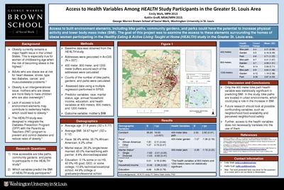
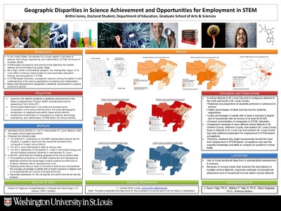
Access to Health Variables Among HEALTH Study Participants in the Greater St. Louis Area
Emily Walk and Kaitlin Graff
2-5-2015Access to built environment elements, including bike paths, community gardens, and parks could have the potential to increase physical activity and lower body mass index (BMI). The goal of this project was to examine the access to these elements surrounding the homes of obese women participating in the Healthy Eating & Active Living Taught at Home (HEALTH) study in the Greater St. Louis area.
-

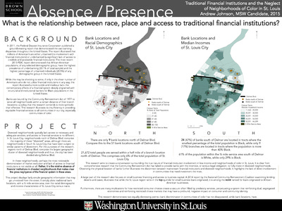
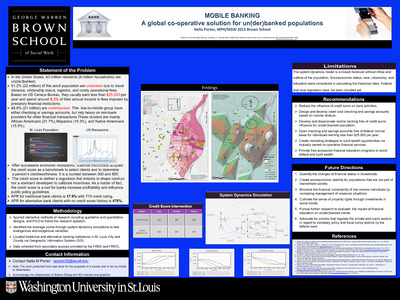
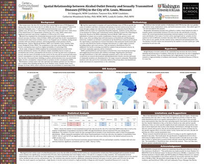
Absence Presence: What is the relationship between race, place and access to traditional financial institutions?
Andrew Johnson
12-9-2014In 2011, the Federal Deposit Insurance Corporation published a groundbreaking report that demonstrated the vast banking disparities throughout the United States. The report illustrated that millions of American’s are either unbanked (no involvement with financial institutions) or underbanked (a significant lack of access to credible and accessible financial institutions). The most recent 2013 FDIC report demonstrated that African-American populations, of any selected demographic group, have the highest prevalence of underbanking (33.1% of total sample) and the highest percentage of unbanked individuals (20.5%) of any demographic group in the United States. Banks are bound by the Community Reinvestment Act of 1977 to serve all neighborhoods within a certain distance of their branch locations– a policy that this research contends is more symbolic than effective. This research illustrates its insufficiency in providing equitable financial services to all communities in our city, especially communities of color.
-

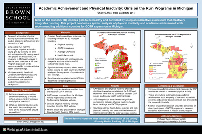
Academic Achievement and Physical Inactivity: Girls on the Run Programs in Michigan
Chenyu Zhao
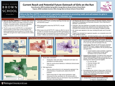
12-9-2014Girls on the Run (GOTR) inspires girls to be healthy and confident by using an interactive curriculum that creatively integrates running. This project conducts a spatial analysis of physical inactivity and academic achievement while recommending additional counties for GOTR expansion in Michigan. The research examines whether there is a negative correlation between elementary to middle school achievement in Michigan and physical inactivity? What are potential counties with low health factor rankings that Girls on the Run (GOTR) should expand into?
-

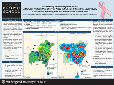
Accessibility to Mammogram Centers: A Network Analysis Using Service Areas in St. Louis City and St. Louis County
Salma Abadin
12-9-2014Among women, breast cancer is the most common noncutaneous cancer and second most common cause of cancer-related death. The American Cancer Society recommends that women over age 40 have a mammogram annually. Early detection and treatment of tumors has been associated with a 15% decrease in breast cancer mortality. Mammography screening rates have remained at 67% over the past several years but is lower among African American and uninsured women. This project locates mammogram centers in St. Louis City and St. Louis County, aims to determine the concentration of women over 40 years per 100,000 population and to calculate drive time from the mammogram center to discover any underserved areas.
-

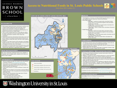
Access to Nutritional Foods in St. Louis Public Schools
Shikha Mittal
12-9-2014While research indicates that many critical factors contribute to the complexity behind explaining the achievement gap, current research in the United States overlooks the importance of addressing food insecurity as an important contributing factor for academic success known as “hidden hunger”There is a lack of research about how to most effectively address the needs of youth that do not receive nutritional foods in order to bbe healthy and productive members of their schools and communities International research has indicated that nutrition plays a key role in positive cognitive development including improved attention and episodic memory, among other factors, that lead to better academic performance Though St. Louis Public Schools (SLPS) participate in the Healthy, Hunger-Free Kids Act of 2010, students are still not receiving food with adequate nutritional value in some regions Food Deserts: Low-income census tract with limited access to food, determined by the distance from a certain location (i.e., schools) to a grocery store, supercenter or supermarket (USDA, 2010). This project asks how does satisfactory nutritional food access compare in elementary and secondary public schools in St. Louis city and St. Louis County?
-

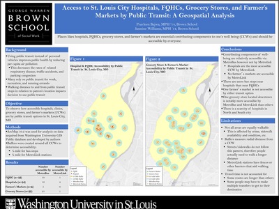
Access to St. Louis City Hospitals, FQHCs, Grocery Stores, and Farmer’s Markets by Public Transit: A Geospatial Analysis
Pravleen Bajwa and Jasmine Williams
5-4-2014This project observes how accessible hospitals, clinics, grocery stores, and farmer’s markets (CCWs) are by public transit options in St. Louis City, MO.
-

ACCESS TO TERTIARY EDUCATION FOR BLACK AFRICANS IN POST-APARTHEID SOUTH AFRICA: SOCIAL ISOLATION AND CONCENTRATION EFFECTS
Ashley Macrander
12-12-2014Tertiary education access in South Africa under the apartheid system was dichotomized along racial lines. Black universities were designed to inculcate racial ideology and state policy; whereas, White teaching and research institutions served to advance the political and economic opportunities of those who attended. This project aims to discover how Black African and White communities are spatially segregated from one another, likely resulting in social isolation; Investigate how language, HIV, and poverty are concentrated in Black African communities; determine how social isolation and the presence of concentration effects among Black Africans perpetuates apartheid inequalities in access to tertiary education.
-

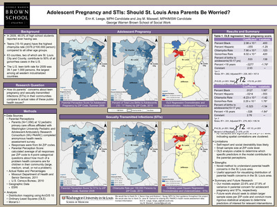
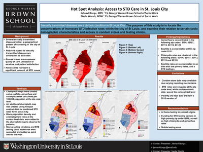
Adolescent Pregnancy and STIs: Should St. Louis Area Parents Be Worried?
Erin K. Leege and Joy M. Maxwell
12-12-2014In 2009, 46.0% of high school students reported ever having sex. Teens (15-19 years) have the highest chlamydia rate (3378.2/100,000 person) compared to all other age groups. 63 counties, two of which are St. Louis City and County, contribute to 50% of all gonorrhea cases in the U.S. The U.S. teen birth rate for 2009 was 39.1 per 1,000 persons, the largest among all western industrialized countries. This project asks whether pregnancy and sexually transmitted infections (STIs) in their communities compare to actual rates of these public health issues?
-

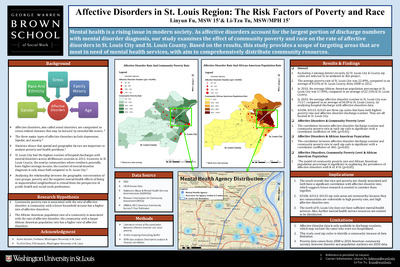
Affective Disorders in St. Louis Region: The Risk Factors of Poverty and Race
Linyun Fu and Li-Tzu Tu
5-4-2014This project examines whether community poverty rate correlates with the rate of affective disorder; a community with a lower household income has a higher rate of affective disorders. It also studies the African American population rate of a community is associated with the rate of affective disorder; the community with a larger African American population rate has a higher rate of affective disorders.
-

Analysis of Adolescent Pregnancy Hot Spots in Honduras
Kate Clitheroe
5-4-2014This project examines whether adolescent pregnancies in Honduras spatially clustered and where spatial correlation between maternal education, wealth, contraceptive use, access and adolescent pregnancies in Honduras is explored.
-

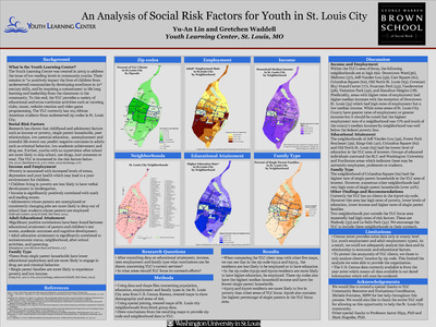
An Analysis of Social Risk Factors for Youth in St. Louis City
Yu-An Lin and Gretchen Waddell
12-12-2014Through consultion of data on educational attainment, income, teen employment and family type this project asks what conclusions can be drawn concerning YLC’s current services? In what areas should YLC focus its outreach efforts?
-

A Spatial Analysis of How Public Investments Target Regional Poverty in Albania
Dauti
12-12-2014This poster explores what regions are more likely to be targeted by public investments. Does targeting vary across types of public investments? Are the poorest regions more likely to be targeted by public investments? How does the relationship between poverty and targeting vary across types of public investments?
-

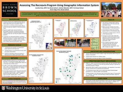
Assessing The Recreovia Program Using Geographic Information System
Carolina Paez, Andrew Nylander, and Aaron Hipp
12-12-2014The Recreovia program started in 1994 in Bogota, Colombia as a complementary strategy to promote active living by providing free physical activity classes in community settings (i.e., parks, community/shopping centers, streets) five days a week. This program serves the entire community regardless of ethnicity, age, gender or socioeconomic status with a health-focused and culturally oriented educational approach.
-

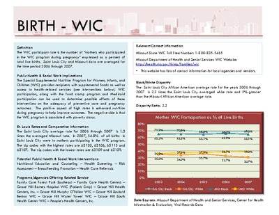
Birth-WIC
Amanda Maust
12-12-2014This study examines WIC eligibility, which extends beyond mothers to children up to five years of age with nutritional risk, and participation. The number of children living in grandparent-headed households increased 30% between1990 and 2005, half are under age six, and their households have higher poverty rates than other family type households (Hayslip & Kaminski, 2005). Research conducted on TANF and food stamps has shown that although grandmother-only no parent families are most likely to be poor, they are less likely to receive benefits (Brandon, 2005). If the same pattern is true of WIC participation, young children with nutrition risk who are living with grandparents may be underutilizing the program. Locating these families geographically could help target outreach efforts.
-

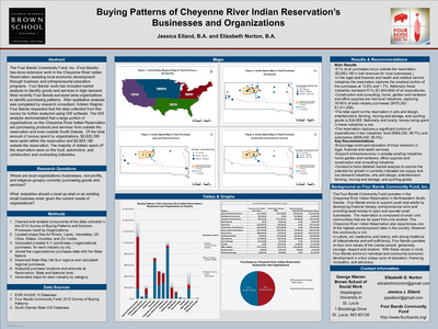
Buying Patterns of Cheyenne River Indian Reservation’s Businesses and Organizations
Jessica Eiland and Elizabeth Norton
12-12-2014The Four Bands Community Fund, Inc. (Four Bands) has done extensive work in the Cheyenne River Indian Reservation assisting local economic development through business and entrepreneurial education programs. Four Bands’ work has included market analysis to identify goods and services in high demand. This project asks where are local organizations (businesses, non-profits, and religious groups) currently purchasing goods and services? What industries should a local up-start or an existing small business?