

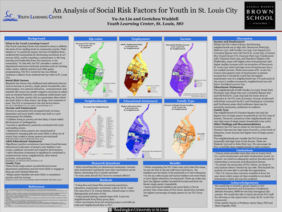
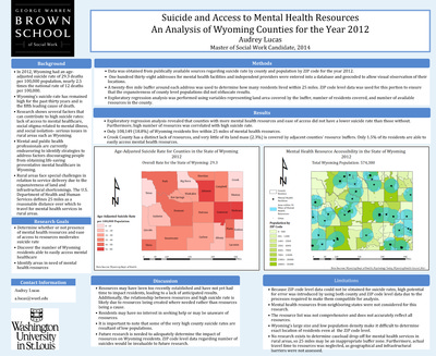
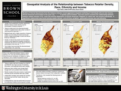
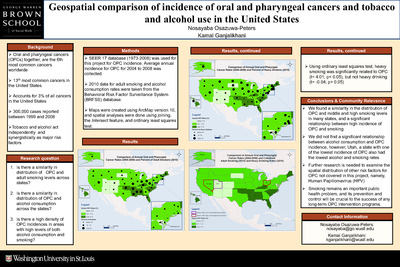
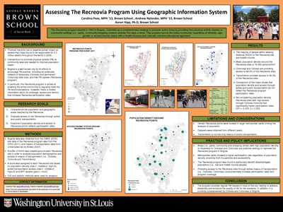
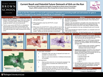
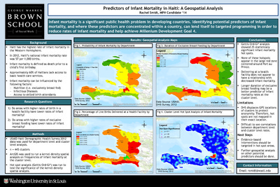
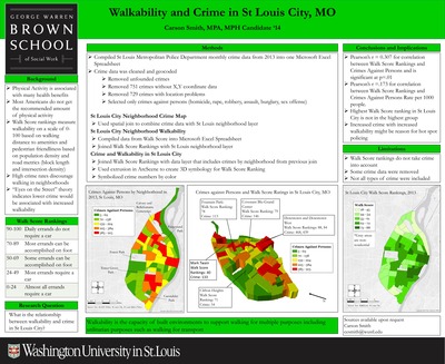
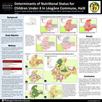
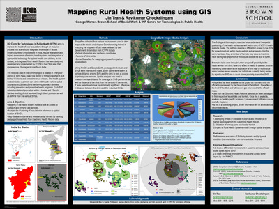
Course description: This course will familiarize students with the basic knowledge of geographic information systems (GIS) and their application to social work practice and research. The course is organized around three primary areas: 1) conceptual; 2) technical; and 3) data management. A conceptual overview of GIS is presented to provide students with foundational knowledge about the theory, purpose, function, and applicability of GIS in practice and research settings. Students will develop critical thinking skills necessary to devise research questions appropriate for a GIS, to develop a GIS, interpret the findings, and to evaluate the spatial relationships between variables.
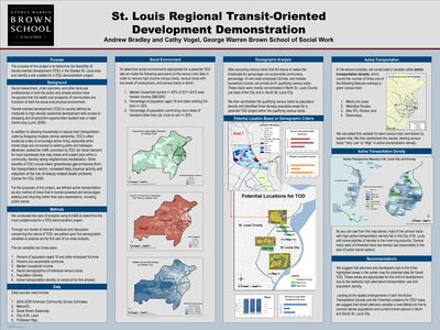
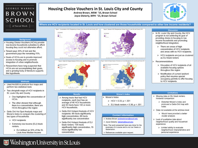
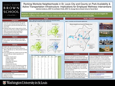
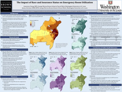
If you created a poster before Spring 2015 and would like to make it openly available (Unrestricted) online, please submit the linked Consent Form to digital@wustl.edu.
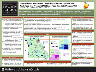
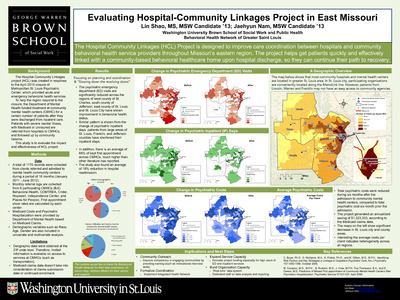
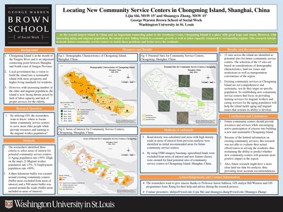
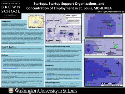
-

Flood Plain Demographics Surrounding St. Louis, Missouri
Caroline Olstad
12-1-2013The aim of this project is to determine how many people are living in a 100-year flood plain in the St. Louis, Missouri region and to determine the racial and socioeconomic demographics of people living in a 100-year flood plain to target flood preparedness interventions.
-

A Walk in the Park: Extent and Distribution of the Parks and Recreation Facilities Supported by the Municipal Park Grant Commission of St. Louis County
Christine O'neil
5-7-2013This project investigates how many individuals live within walking distance (0.5 miles) of a Commission-funded project, how many of these individuals are children or youth below the age of 18, if the communities in the immediate vicinity of Commission-funded projects are demographically similar to St. Louis County as a whole, and specific demographic factors to be analyzed include age, race, and median household income.
-

High Risk Areas for Human Sex Trafficking Activity In Southwestern Illinois
Ambar Plasencia
12-2013Human trafficking is often explained as “modern‐day slavery”. It involves the forced exploitation of a person for a service. Through research and close analysis of case studies, experts have been able to identify salient risk factors that tend to increase the risk of human trafficking activities.
The aim of this project is to identify potential areas of high risks for human sex trafficking in southwestern Illinois, in hopes of better equipping law enforcement and social service agencies in combatting sex trafficking.
Located businesses associated with a high base risk for trafficking activities,and identified clusters of these within a 0.5 mile radius from any state road or interstate highway.
-

Broadband Internet Availability and Accessibility in the State of Missouri
Anjila Prasai
12-1-2013The goal of this project is to identify areas in the state of MO where broadband internet services are available. Locate public libraries in the state of MO with broadband internet accessibility, rank Missouri counties based on high poverty, low educational attainment, and high unemployment rate, and identify any correlation with high speed internet availability and accessibility.
-

Penrose Park Velodrome
Andrea Roelofs
12-1-2013This project aims to identify characteristics of those people living within a walking distance from Penrose Park; identify comparable Velodromes in the United States to serve as a model for redevelopment; provide research for the Penrose Park Steering Committee.
-

Targeted Outreach: Grassroots Organizing for theSierra Club Anti-Pipeline Campaign
David Schafroth
7-1-2013The goals of this project are Geocoding the Flanagan South Pipeline, Geolocating individuals who will be most impacted by the proposed pipeline, and creating a database for the Sierra Club to prioritize outreach efforts.
-

Do Vacant Land Improvement Efforts Affect Crime Rates?
Breann Schubert
12-1-2013This project examines how are St. Louis City vacant land improvement efforts affecting nearby crime rates.
-

Positive and Negative Community Facilities and Their Relationship to Crime in the Isaac School District
Dessa Somerside Schuckerow
7-1-2013This project aims to answer the following questions: are there blocks with higher crime incidences in the Isaac School District? What is the relationship between the high-crime blocks, schools, community resources, and facilities with liquor licenses?
-

Mapping the Youth Control Complex: Or, the failure of large scale surveys
Masha Serdyukova
5-7-2013This project studies the quesiton of how the YCC impacts urban youth compared to suburban and rural.
-

Crime and Refugee Disparity in St. Louis
Andrew Sheeley
7-1-2013The aim of this project is to determine the degree of spatial separation between European and Non-European refugees and to measure the degree to which refugees in St. Louis City are exposed to crime as opposed to those residing in St. Louis County.
-

St. Louis Arc Supported Employment: Locating Undeveloped Areas for Potential New Job Sites
Jessica Steinberg
7-1-2013This project investigates which areas of the Greater St. Louis Metropolitan region would be the most effective places for the St. Louis Arc Supported Employment program to focus job site development.
-

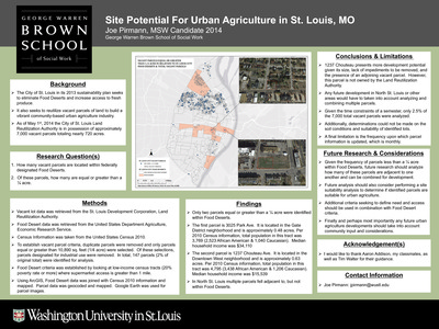
Expanding Farmers’ Markets in St. Louis City and County
Alyssa Tutterow
7-1-2013This project asks the following questions: what are the typical neighborhood characteristics in farmers’ market locations? Where could an additional farmers’ market be located in order to serve the community and be a successful business?
-

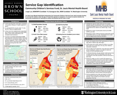
Meeting the Hispanic/Latino Mental Health Needs in the City of St. Louis
Ana Vargas
7-1-2013This project seeks to identify mental health risk factors for the Hispanic/Latino population, locate current bilingual mental health services in St. Louis, and conduct an analysis on areas with large Hispanic population growth and low medium household income in relation to identified mental health services.
-

Redevelopment in North St. Louis City
Jacqueline Wagner
12-1-2013This project seeks to answer the following questions: what is the current state of property in the study area? What areas may be best suited for redevelopment? What types of redevelopment are suitable and feasible?
-
 Restaurant Meals Program (RMP)(San Diego County - Zip Code 92105) by Timothy P. Walter")
Potential Outreach Sites for CalFresh (SNAP) Restaurant Meals Program (RMP)(San Diego County - Zip Code 92105)
Timothy P. Walter
7-1-2013This project examines the potential qualifying food options within zip code 92105. It asks where are the cluster zones of potential RMP sites within Homeless & Senior buffer zones.